Showing posts with label Beautiful Island In The World. Show all posts

Milford sound and the Mitre peak

Monday, June 6, 2011

0 comments
Milford sound and the Mitre peak
country : New Zealand
place : south-west of the southern island


Fill a tumbler full of water from a waterfall cascading from rocks hundreds of metres above your head on a scenic cruise of the Milford Sound and you will know what it really means to be a New Zealander. Taste its pure flavour and you'll know you're in the Milford Sound.
The scale of the landscape in Milford Sound is phenomenal. Large cruise boats look extremely insignificant against the grandeur of Mitre Peak and the walls of this mighty fiord. Its steep rock walls plunge vertically for hundreds of metres both above and below the water line, allowing cruise boats to maneuver beneath the falls.
In 1986, UNESCO bestowed World Heritage status to this region in recognition of its "superlative natural phenomena" and "outstanding examples of the earth's evolutionary history."

This description is not lost on international visitors who flock here from all over the world. Neither is it lost on locals, no matter how often they have visited.

There�s a wide array of cruises on offer in Milford � ranging from scenic cruises and extended daytime cruises with a nature guide, through to overnight excursions with the option of exploring by kayak or tender craft.
However, Milford Sound is not only remarkable above the water, it also has a unique marine environment.
This underwater world is most easily viewed from the Underwater Observatory. It features a spiral staircase that descends for more than seven metres under the water surface to an observation deck.

The deck is fitted with windows to view rare marine life such as Black Coral, which occurs much closer to the surface than deemed normal, thanks to a layer of fresh tannin water which filters light.
For those who wish to get right amongst it, there's also the option to take a guided dive, or explore the grandeur of this magnificent sound by kayak.

The scenic icon of New Zealand is the picture-perfect view of Mitre Peak mirrored in the glassy waters of Milford Sound.

Milford Sound�s majestic grandeur is symbolised by the perfection of this scene of sheer rock walls, 1700 metres high, plummeting into the black depths of the fiord. No wonder author Rudyard Kipling described Milford as the eight wonder of the world, and Arthur Michener thought of it as �the most stirring sight in the Pacific�.

The majestic scenery begins long before you reach Milford, in the Eglinton Valley. Snow-capped mountains loom 1000 metres above the road, streaked with waterfalls, and reflected in mirror lakes. The road climbs steeply into a sub-alpine wonderland at the Homer Tunnel entrance. You emerge from the tunnel to an instantly breathtaking view of the canyon which descends into Milford.

Milford Sound comes a close second to the mountains of Tahiti in recording the highest rainfall in the world. The deluge of 7 metres of rain each year sounds forbidding for a tourist resort, but it actually adds to the drama and mystique of the sound. In torrential rain the sheer mountain walls erupt with a thousand cascades plunging from hanging valleys, wreathed in ethereal mists, and crossed with rainbows.

A boat cruise is the best way to appreciate the grandeur of the sound. Highlights include Bowen Falls, Mitre Peak, Anita Bay, The Elephant and Stirling Falls. In Harrison Cove there is an underwater observatory with views of aquatic life on the reef. Some cruises go out to the entrance of the Sound where dolphins, fur seals and crested penguins may be seen.
Kayaking and diving trips can be arranged and divers have the rare opportunity of seeing black coral at relatively shallow depths. Scenic flights take in the other main sounds down the coast, and the Sutherland Falls, which are New Zealand�s highest.

The 55 km Milford Track, reputed to be �The Finest Walk in the World� operates in the summer months. It takes three days and links Lake Te Anau with Milford Sound.
Milford Sound provides a rare chance to get a close view of nature on a grand scale. It�s the ultimate in scenic splendour in a country that excels in mountain grandeur.


Free Template Blogger collection template Hot Deals BERITA_wongANteng SEO theproperty-developer

The Galapagos archipelago

Tuesday, May 24, 2011

0 comments
The Galapagos archipelago
country : Ecuador
place : off the west coast of the country


The Galapagos Archipelago is situated 800 kilometers west of the Ecuadorian coast and lie directly on the equator. The archipelago encompasses over 50 islands of volcanic origin that are spread out over an area of about 4,500 square kilometers. The volcanic Galapagos platform originated probably not more than 15 million years ago and the oldest island not more than 2.4 million years ago. Volcanic eruptions still occur in the islands. Isla Fernandina and the Sierra Negra volcano on Isla Isabela have erupted within the past 10 years.


The Galapagos Islands are an archipelago consisting of some 16 islands and numerous islets scattered over an area of nearly 36,000 square miles around the Equator. Each major island, with the exception of the largest island, Isabela, consists of a single large shield volcano. Isabela was formed from six volcanoes joined above sea level. The total land area of all the islands, islets and rocks that form the Galapagos Islands is about 3,028 square miles, with Isabela making up more than half the total land area, at 1,700 square miles. The islands all rose from the ocean floor as the tops of volcanoes, possibly during the Pliocene era, and have never been connected by land to any mainland area. Today, the Galapagos Islands remain one of the most active oceanic volcano areas on Earth.


Just as the extraordinary wildlife of the Galapagos Islands is critical to the study of biology, the unique geology of the islands has implications for the whole planet. In geological terms, the Galapagos Islands are quite young, probably no more than five million years old. Some of the westernmost islands, which are the most volcanically active, may only be hundreds of thousands of years old and are actually still forming. Fernandina, for example, at its current rate of activity, may one day expand to meet the shores of Isabela, creating a single, large island. As these amazing changes take place, scientists can observe the effects of the tides, wind and weather on the process. They are then better able to define the impact of the environment on both the Galapagos Islands and, by extension, the Earth. More importantly, these studies can help scientists develop ways to protect the environment in our ever-changing world.


Though the islands are now quite isolated, at 600 miles from the nearest mainland, some biologists believe that the Cocos Ridge, which runs under the sea and extends almost the entire distance from Costa Rica to the northern islands, was once a land bridge. These biologists use this theory to explain how some of the life on the Galapagos Islands arrived there, but it has not yet been proven. Although many species of flora and fauna that thrive on the Galapagos Islands resemble those native to South America, they have evolved so extensively in isolation that they now appear very different from their mainland ancestors.


There are four main ecosystems in the Galapagos Islands, which have been formed over time by wind patterns and differences in elevation. The first ecosystem is made up of arid lowlands and open forests of enormous cacti; the second consists of subtropical forests; the third, found at higher elevations, is composed of moist, dense forests; and treeless upland areas covered with ferns and grasses make up the fourth. Goats, pigs, and other introduced species left by 19th century sailors to multiply on the islands and serve as a source of fresh meat on later visits eventually destroyed much of the native vegetation on many of the islands. The remaining areas consist of little more than bare, hardened lava, which has formed cliffs and jagged points of land along the coasts. Volcanic activity has produced several thousand calderas and cones throughout the archipelago, the largest of which may be found on the islands of Isabela and Fernandina. These unusual landforms give the landscape of some islands an almost lunar quality.


Free Template Blogger collection template Hot Deals BERITA_wongANteng SEO theproperty-developer

Karstic peaks at Guilin, along the Li river

Thursday, May 19, 2011

0 comments
Karstic peaks at Guilin, along the Li river
country : China
place : south of the country, between Guilin and Yangshuo


Well-known both home and abroad for its verdant hills, limpid waters, fantastic caves and exquisite rocks, Guilin has enjoyed the reputation of having the country's most beautiful scenery for hundreds of years. Guilin is a bright pearl on the list of China's top tourist attractions and the Li River is the highlight of sightseeing tours in Guilin. Originated in Mao'er (Cat) Mountain in Xin'an county northeast of Guilin, the Li River winds its way southeast for about 426 km.
Li River cruise takes visitors from Guilin to Yangshuo. A state-level scenic area, it is the centerpiece of your Guilin tour, as well as one of the highlights of any China tour. This section of the Li River appears like a classic Chinese ink painting with its green hills, crystal water, verdant bamboo and clear water reflection. The great Tang Dynasty poet Han Yu vividly described the landscape as "the river winds like a green silk ribbon, while the hills are like jade hairpins".


From Guilin to Yangshuo, the Li River gracefully flows over 83 kilometers and the banks of the river offer the most beautiful scenery. The natural beauty of the Li River is indeed beyond description. You will have to visit this amazing place, to witness it with your own eyes and to feel with your own heart.


The comfortable Li River cruise will take approximately 4 hours, carrying you away from the bustle of city life and into a peaceful and relaxing world. The only thing you need to do is bring your imagination, a camera, and keep your eyes open, as the stunning Karst landscape will give you a surprise around each bend of the Li River flows under the clear blue sky. Your tour guide will tell you the legends behind the different peaks, most of which are mythical tales, and love stories. For example: Wangfu Rock (yearning for husband's return) is so-named because it looks like a woman carrying her baby on her back and yearning for her husband's return after a long day of working on the river.


The Crown Cave (Guanyan):
Crown Cave, located 29km south of Guilin city, is relatively new to the Guilin tour industry, having been opened to public in 1995. Visitors can get there by bus from Guilin or making a stop at the Crown Cave Dock during your cruise along the Li River.


Half-Side Ferry (Ban Bian Du):
Not very far from the Crown Cave on the western bank, a huge rock descends into the river and cuts off a footpath by the water edge. Villagers have to take a ferry to reach the other side and continue on their way. It has been named Half-Side Ferry. The ferry precipices of the Half-Side Ferry are cut so smoothly that they seem to have been cut by a knife. It is a rare natural occurrence.


Cruising down the Li River from Guilin to Yangshuo, you will see local fishermen at work on their simple bamboo rafts.
Nine Horse Mural Hill:
The hills and peaks in Guilin, crafted by nature, rise sharply from the ground in many different shapes. Each famous peak along the Li River has been given a name based on its shape.


Some peaks however require a great deal of imagination to see how it got its name. One of the most famous peaks along the Li River is the 416-meter-high Nine Horse Mural Hill. The precipice of the Mural Hill is even and straight as if cut by knife, decorated with colors of white, yellow, gray and black. Images of nine horses may be seen indistinctly on the precipice, hence the name Nine Horse Mural Hill.


Yellow Cloth Shoal:
Floating downstream, after passing Mural Hill, you will find the Yellow Cloth Shoal. The cliffs are steeper and the river becomes wider and calmer here, so it is the best place to appreciate the reflections of the verdant peaks. It is no wonder that the newly-issued RMB20 note carries the image of this part of the river. The water is so limpid that the reflection of a huge yellow flagstone can be clearly seen on the water. It is like a yellow cloth spreading across the countryside, hence the name Yellow Cloth Shoal.


Xingping:
As you reach the area surrounding Xingping village, some of the most striking scenery along the Li River comes into view. The short distance between Xingping and Yucun villages is the highlight of the cruise.


The river takes a big turn at Xingping and the beautiful landscape and country scenery will form a lifelong impression on visitors. Verdant bamboo greet visitors along the river while water buffalo eat grass casually on the fields, peasants harvest their crops, school children play on the way home, and fisherman float along on bamboo rafts with their cormorants.


Yucun (a fishing village):
A pretty village of Yucun on the left bank of the river is worth a visit. The villagers all have the same surname of Zhao. The 500-year--old village, which can only be reached by boat, was a highlight of American President Bill Clinton's cruise down the Li River in July of 1998.


Most of the courtyard buildings in the village were built during the Ming (1368-1644) and Qing (1644-1911) Dynasties. Simple but elegant with flying eaves, carved beams and windows, these buildings are ancient architectural wonders. Visitors are often surprised by the openness and generosity of the villagers, when they find themselves warmly greeted by farmers in any farmhouse they call at.
Both Dr. Sun Yet-sun, the pioneer of China's democratic revolution, and former US President Clinton visited this Chinese tourism Mecca. They are really a great advertisement for Yucun. The President stated he was greatly impressed with the popularization of biogas and solar energy in Yucun, which has completely replaced wood as the fuel for the 120 households in the village.


Destination � Yangshuo County:
Yangshuo is the Li River cruise's destination. It is located 65 kilometers south of Guilin city.


An ancient saying goes "Guilin has the most beautiful scenery in China, but the landscape of Yangshuo is unmatched in Guilin". It is this unmatched landscape that has made this small county known to the world.
The perfect way to appreciate its beauty is by bicycle, as the scenery along the road is dramatic and the natural beauty is truly beyond description.
Yangshuo is an ideal place for moderate hiking or cycling excursions to get a taste of genuine rural life.


It is a wonderfully pastoral area, with small villages. In most of these villages, even new buildings tend to use the older style of architecture. The owners are often keen to show visitors around.


Things to see and do in Yangshuo:
In Yangshuo, there is a 1500-year-old Big Banyan Tree whose branches and roots spread over a large area close to the river. Moon Hill (Yueliangshan) is a great limestone pinnacle with a naturally-created moon-shaped passage going through just below its summit. Fascinating Yinzi Cave (Silver Limestone Cave), 3 kilometers away from Yangshuo County, was praised by French experts on karst geology as "a world treasury of karst caves".


If you stay overnight in Yangshuo, West Street and Impression Liu Sanjie are two attractions not to be missed.
West Street of Yangshuo is an old street with a history of more than 1,400 years. Every year hundreds of foreign visitors come to live here for a while and some of them settle down permanently in this small county just to enjoy its leisurely life and keep in touch with nature. A special feature on the street is the communication and interchange between Chinese and foreign cultures. You can learn Chinese, calligraphy, tai chi, cooking, and Chinese chess, while passing international languages and cultures to Chinese in bars, shops, or schools. Because of this, people in China called it "Foreign Street". West Street is lined with Chinese and western cafes, restaurants and hotels. It is a seamless blend of eastern and western culture and has helped give the area a "global town" image.


Impression LiuSanjie (Third Sister Liu), directed by the China's most famous movie director Zhang Yimou, is an outdoor performance on the natural stage setting formed by the Li River and 12 peaks. This performance expresses the beautiful scenery of the Li River, and the colorful culture of the ethnic groups in Guangxi by creatively combining the classical Third Sister Liu''s Songs, ethnic minority culture, and the lights of traditional fishermen on the river, to reflect the harmonious atmosphere between human beings and nature. The performance lasts for 70 minutes and over 600 actors and actresses are involved.


Guilin Featured Tour Packages


Guilin China is well-known for its dramatic Karst topography, the picturesque natural skyline of Guilin City, the limpid Li River, and the "global village" Yangshuo. At Longsheng County, Longji Terraced Rice Fields extends to as far as eyes can reach.
Want to see the best of Guilin? China Odyssey Tours provide all kinds of tours in Guilin. We provide both pre-designed city tour packages and flexible tailor-made tours


Source: http://www.chinaodysseytours.com


Free Template Blogger collection template Hot Deals BERITA_wongANteng SEO theproperty-developer

Bali island

0 comments
Bali island
country : Indonesia
place : east of Java island


Bali islands is one of the thousands islands constructing the Indonesian Archipelago that has long been famous as a leading tourist destination in South Pacific or even in the world for its exotic and vibrant art and culture, natural beauties and the hospitality of the people. Bali islands covers an extent of 5,632.86 square kilometers consisted of mountain range stretches from the West tip to the East.
Hinduism is adhered by almost 95% of its population of more than 3 millions people, specifically blended with Buddhism and the Ancestor's worship. It is made inseparable from everyday life and no opportunity is missed to worship Gods in an unending series of ceremony stretches from birth up to after death.
The Conducive environment in Bali islands is supported by the Balinese philosophy of life, called "Tri Hita Karana". Tri Hita Karana dictates that happines can only be achieved if there are hamonious relationship between human and Gods; between human and their community; and between human and nature (its surronding). This philosophy has become a way of life among the Balinese, and is practiced in their daily life.


Bali islands has such a mild and agreeable climate the wholeYear round, with average temperature of the day in coastal areas varies from about 28C (82F) during May-July to abut 30C (86F) in March-October, while the most pleasant weather is between May-September.


Nusa Dua (Bali islands) is an exclusive resort area featuring pristine beaches and majestic palms overlooking a turquoise sea. This purpose-built development is a peaceful enclave where families can relax and enjoy a tropical paradise and the Balinese hospitality, all without having to venture far from their luxurious rooms. The Bali Golf and Country Club is only a few steps away and the International Airport is a mere 20-minute drive from Nusa Dua.


Ubud (Bali Islands) is a remarkable town inthe middle of the island of Bali. For more than a century, it has been the island's preeminent centre for fine arts, dance and music.While it once was a haven for scruffy backpackers, cosmic seekers, artists and bohemians, Ubud is now a hot spot for literati, glitterati, art collectors and connoisseurs. Famous names walk its busy sidewalks everyday.


Sanur (Bali islands) is traditionally a fishing village and has managed to keep that lazy-town feeling. This really makes Sanur a unique area and unlike most other beach areas in Bali, Sanur has stayed largely in local hands.


Tanah Lot (Bali islands), Located in Tabanan, just across the boundary of Badung regency, Tanah Lot is the most well-known and photographed temple. The temple is built on a small promontory, which is only accessible by foot at low tide. Take a scarf and dress with respect.


Menjangan island (Bali islands) popular diving site in Bali due to it's fine and preserved corals and rich equatic animal, turquoise clear water, and very calm sea. Every divers coming to Bali with the emphasize on diving program in Bali will put Menjangan and Tulamben sites as the priority sites. Menjangan island is unpopulated, but there is an old temple, supposed to originated from 14th century named " Pura Giri Kencana." During the expedition of Majapahit kingdom of Java in 1343 AD, it is believed that a boat was wrecked with their relics are still on sea bed. It is believed to have the magic influence.


Nusa Lembongan (Bali islands) is situated 12 miles south east of Bali. It is one hour travelling time by boat from Benoa Harbour. This pear shaped island is around 4km long and 2km wide. It is surrounded by a beautiful fringing reef and the waters are renowned for their abundance of life and great surf breaks.


Candidasa (Bali islands) is most often compared to Kuta as Kuta was some 15 years ago. The comparison has some merit - Candidasa is a small village with few inhabitants on the beach with a several - mostly inexpensive hotels that cater to more adventurous tourists looking for a more laid back atmosphere.


Bali, a tropical island in the Indonesian archipelago, is so picturesque and immaculate it could almost be a painted backdrop. It has rice paddies tripping down hillsides like giant steps, volcanoes soaring up through the clouds, dense tropical jungle, long sandy beaches, warm blue water, crashing surf and friendly people who don't just have a culture but actually live it. In Bali spirits come out to play in the moonlight, every night is a festival and even a funeral is an opportunity to have a good time.


Bali Island, the perfect holiday destination for all ages offers something for everyone. This tropical paradise has a unique blend of modern tourist facilities combined with wonderful shopping and a rich past and heritage. The Balinese people are proud of having preserved their unique Hindu culture against the advance of Islam, the dominant religion throughout Indonesia. This is still reflected in day to day life and can be seen in the numerous ceremonies, Balinese festivals and magnificent temples and palaces. Some of the best surfing beaches in the world can be found on the western side of the island whilst conversely the eastern side is a wonderful haven for families, with beautiful white sand beaches and gentle seas.


Bali Island is a shopper's paradise particularly for casual and tailored clothing, locally made jewellery, handicrafts, antiques and artifacts. Leather ware is one of the unexpected local bargains with everything from handbags through to tailor made leather jackets and coats, all at unbelievable prices. In fact, prices are so inexpensive, you're sure to need more room in your suitcase! Try bargaining at the street markets of Kuta, Sanur of Nusa Dua or fixed price shopping at a Denpasar department store. Bali has it all.
For those that want to stay wet, Bali Island has world class scuba diving, snorkelling and wonderful day trips out to Nusa Penida for beach sports and coral viewing.


When the sun sets, the choices are still hard to make - a quiet romantic moon lit dinner or watch the spectacular Balinese Fire Dance or Kecak Dance. For those that want to party, Bali Island has it all with bars, discos and nightclubs.


As a truly international destination attracting visitors from all over the world, restaurants in Bali are extremely cosmopolitan yet inexpensive. Experience not only local delicacies like Nasi Goreng and Sate Campur but also Chinese, Malaysian, Japanese, Italian/European Greek, Moroccan and even Mexican cuisine. We must not forget Bali's wonderful seafood - local lobster at such prices that you will want to keep coming back for more.
For those more culturally inclined, Bali can offer the peace and tranquility of Ubud high in the hills; the spectacular Mother Temple at Besakih; the ancient capital of Bali, Singaraja and the floating palace at Ujung near the pretty beach area of Candi Dasa. The Scenery is nothing less than spectacular. Jungle, picturesque hillside rice terraces and the awesome magnificence of Kintamani Volcano.


The more active, wanting a break from the idyllic beaches, can experience wonderful golf courses in the mountains at Bedugul and beachside at Nusa Dua, the thrill of white water rafting or kayaking down the beautiful Ayung River; mountain cycling amid scenery you will never forget and organized rice paddy and jungle treks to see the side of Bali most tourists never encounter.
Bali Island, a truly international destination, offers every standard of accommodation ranging from charming yet modest bungalow style hotels in lush tropical gardens for the budget minded through to arguably amongst the most exclusive and sophisticated hotels in the world.


Source:
http://www.baliisland.org/
http://www.all-bali.com/


Free Template Blogger collection template Hot Deals BERITA_wongANteng SEO theproperty-developer

The Bora-Bora island

0 comments
The Bora-Bora island
country : French Polynesia
place : in the middle of the Pacific


Your really do deserve a vacation to Bora Bora. Don't fight it, you know it's true...
Bora Bora island is possibly the single most famous island in all the world. The legends, mysteries, and romance associated with the words "Bora Bora" bring an almost mystical presence to the island.
It's true Bora Bora is indeed a wonderful place to vacation... but this magical presence is not so unattainable.
Facts from the fiction regarding this wonderful Tahiti Polynesian island paradise: Tourism aspects, activities, practicalities, culture, and all the things you'll want to know when planning a trip to Bora Bora. We propose to the would be traveler that the Island of Bora Bora is quite real and attainable as a vacation getaway.


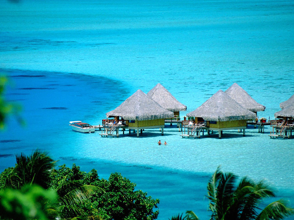
Part of the allure has to be its almost unbelievable beauty. Two towering peaks of sheer black rock dominate the center of the island and make an impressive backdrop to an assortment of blue waters that will dazzle the eyes.
Bora Bora's lagoon is its most treasured feature, and allows the traveler many opportunities to experience it in a variety of ways. Windsurf, jetski, scuba dive, snorkel, swim, bask in its warmth... the list goes on.


Bora bora is truly an experience worth having. A wonderfully relaxing place to be as well as a great island for you to experience, your Bora Bora vacation will never be forgotten.


Bora Bora, The Romantic Island


Under a one hour flight from the island of Tahiti or Moorea, the island of Bora Bora, with a lagoon resembling an artist's palette of blues and greens, is love at first sight.Romantics from around the world have laid claim to this island where the castle-like Mount Otemanu pierces the sky. Lush tropical slopes and valleys blossom with hibiscus, while palm-covered motu circle the illuminated lagoon like a delicate necklace. Perfect white-sand beaches give way to emerald waters where colored fish animate the coral gardens as they greet the giant manta rays. This could be easily be described as the center of the romantic universe, where luxury resorts and spas dot the island with overwater bungalows, thatchedroof villas, and fabled ambience.


Simply said, Bora Bora is the most beautiful island in the world.


Pora Pora - the ancient name, meaning "first born," came from legends describing this as the first island to rise when Taaroa,
the supreme god, fished it out of the waters after the mythical creation of Havai'i, now known as Raiatea. Although the first letter "B" does not exist in the Tahitian language, when Captain Cook first heard the name he mistook the softened sound of the Tahitian "P" for "B" and called the island Bola Bola.


Romance on Bora Bora
Truly, the most romantic island in the world. From the dramatic scenery to the privacy and amenities of the overwater bungalows, everything in Bora Bora equals a 10 on the romance scale. Resorts have been welcoming couples for over 40 years and their special amenities have been fine tuned to perfection. From sunrise to sunset, each resort has designed their own blend of unique romantic experiences for their guests to choose from.


For The Visitor, The Majesty of Bora Bora offers:
Enchantment from the neon-lit turquoise lagoon waters with unending days of exploration through snorkeling and diving.
Excitement above the lagoon by outrigger canoe, Boston Whaler, wave runner, jet ski, and dramatic sunset cruises aboard a catamaran sailboat.
Exploration of the panoramic overlooks found by hike or 4x4 accompanied by entertaining local guides.
Discovery of the world-renowned shopping for local and international original art, Tahitian pearls, perfumes and oils, and precious wood handcrafts.


The turquoise water of the lagoons, an exhilarating ride over it by canoes, jet ski or a catamaran sailboat, a sunset view that takes your breath away, cruising along the panoramic views, a vibrant marine life that you can come close to by snorkeling and diving and the souvenir shops that allow you take home the memoirs from here, in short, this is the much acclaimed Bora Bora Island.
The name Bora Bora comes from the Tahitian word Pora Pora, which means �first born�. Legends describe it as the first island to rise when the Supreme God Taaroa fished it out of the waters after the creation of Havai�i. When Captain Cook heard the name, he mistook Pora Pora for Bora Bora and that�s how the name gained currency and is used till date.
As per an early transcription found in 18th and the 19th century accounts, the name of the Island is recorded as Balobolla or Bollabolla.


Location
The Bora Bora Island belongs to the Leeward group of the Society Islands Archipelago of French Polynesia, in the South Pacific Ocean. The Island, stretching to about 18 miles, is surrounded by a lagoon and a barrier reef.
When to go
The Bora Bora Island has a tropical climate that favours tourism all through the year. The Polynesian summer is the wet season here, in the months from November to March. The months of February and March are the hottest months which also record a high amount of rainfall. The Polynesian winter or the dry season comes in the months from May to October.
The dry season is also the peak tourist season here with a number of tourists coming in at that time.
How to go
The Island of Bora Bora has a small airport on the Motu Mute. The airstrip at Motu Mute was built during the World War II, by US marines as a refueling stop on the America to Australia supply line.
You need to take a connecting one hour flight from Papeete in Tahiti Island to get here. Papeete is about 8 hours away by flight from Los Angeles.
Air Tahiti serves a 20 minute flight to Tahiti from Huahine and Raiatea, has regular flights to the Tuamotu Atolls as well as weekly flights to the Marquesas.
From the Motu Mute airstrip, you need to take a short ferry trip to get to the village of Vaitape and then take a shuttle or other means of transport to explore the Island.
While in the Bora Bora Island, you can ask your hotel to arrange a shuttle service for you or you can rent a car, scooter or a bicycle to explore the Island at your own leisure. These rental services are available at the Vaitape Village.


Attractions of Bora Bora Island
The Bora Bora Island is not just a scenic beauty. The Island offers a number of thrilling activities that you can enjoy.
The hotels here can make arrangements for fishing, diving, water skiing, sailing, canoeing, cruising or snorkeling and other water sports of your choice. You can paddle you way on kayaks to the lagoon. You can also opt for cruises.
There are jet tours that you can take for an excursion to the lagoons here and also explore the inland areas through an organized tour.
Snorkeling and diving can give you the joy of swimming with marine life like manta rays, eagle rays, sharks and over one thousand species of tropical fishes in the lagoon of the Bora Bora Island.
Some of the popular snorkeling and diving sites are over the coral gardens in and around the Bora Bora Lagoonarium and the Anau � a site between the former site and Point Haamaire. The lagoon off the eastern side of Motu Toopua and the islet nest to it, the Motu Toopua Iti too are good sites fro both snorkeling and diving.
Off Motu Tapu, the islet south of Teavanui Pass, is the most easily accessible site for diving in the Bora Bora Island. At some distance that can be covered by lengthy boat rides are two more dive site, the White Valley, off the airport and Tupitipiti, to the south east corner on the reef. They are however, meant for expert divers as they can experience strong currents.
The �Aquarium�, a snorkeling site off the southern end of Motu Pitiaau and around Motu Piti Uuuta, is one of the best snorkeling sites of the Bora Bora Island. To reach here, you would need to ride there by boat, or you can walk to the outer reef from the southern tip of Point Matira. Flying Underwater here too is a good snorkeling spot.


You can also go for night dives.
Shopping too can be fun here. The shops here are well known with souvenirs like local and international original art, Tahitian pearls and handicrafts made of wood.
If you are not comfortable diving or snorkeling, or even other wise, you can enjoy the view of coral and schools of tropical fish through a glass bottom boat. Motor boats give you a fast paced way to explore the lagoon.
If you want, you can enjoy the Shark and Ray feeding tours as well as you snorkel.
Going to Motu Tapu, a small islet about a few hundreds yard away form the Island of Bora Bora is just ideal if you want to relax in a secluded surrounding.
Another major attraction of this French Polynesian Island is the Matira Beach, one of the world�s most popular beaches.
There are guided hikes to Mount Pahia and Mount Otemanu, remnants of two extinct volcanoes in the center of the Island, too that you can go for. The Mount Otemanu is the highest point here, measuring about 727 meters. Along the coast are ancient marae temples that are worth a visit.
The ambience of this South Pacific Island of Bora Bora creates a mood that is simply romantic, something that you dream of. The white sandy beaches, the turquoise water of the ocean, the lush green tropical slopes and the rich and vibrant, colourful marine life makes the place look like an artists imagination that has come live from a canvas. The Bora Bora Island is certainly a place you should visit once in your life time.


Source:
www.boraboraisland.com
http://www.tahiti-tourisme.com
http://www.theearthtraveler.com


Free Template Blogger collection template Hot Deals BERITA_wongANteng SEO theproperty-developer

The Halong bay

Wednesday, May 18, 2011

0 comments
The Halong bay
country : Vietnam
place : in the Tonkin Gulf, east of Hanoi

The end of the Vietnam war, and the advent of "Doi moi", Vietnam's policy of opening its economy to foreign trade, means that Westerners and South Vietnamese now have a chance to visit Ha long.
Vinh Ha Long or Bay of the Descending Dragon is often touted by proud Vietnamese as the world's Eighth wonder. One of the main attractions of Ha long is the bay's calm water and the thousands of limestone mountains dotting the seascape.
The Bay's water is clear during the spring and early summer.
Some of the islands are quite large and there are small alcoves with sandy beaches where swimming is possible. Ha Long bay lies in the northeastern part of Vietnam and is 165 Km from Hanoi.

Ha Long literally means descending dragon(s) and according to local myth, the story goes as follows:
Long ago when their forefathers were fighting foreign invaders from the north, the gods from heaven sent a family of dragons to help defend their land. This family of dragons descended upon what is now Ha Long bay and began spitting out jewels and jade.

Upon hitting the sea, these jewels turned into the various islands and islets dotting the seascape and formed a formidable fortress against the invaders. The locals were able to keep their land safe and formed what is now the country of Vietnam.
 The Dragon family fell so much in love with this area for its calm water and for the reverence of the people of Vietnam that they decided to remain on earth.
Mother dragon lies on what is now Ha Long and where her children lie is Bai Tu Long.The dragon tails formed the area of Bach Long Vi known for the miles of white sandy beaches of Tra Co peninsula.

This myth is in line with the Vietnamese myth of their origin Con Rong Chau Tien. This myth describes the union between a king (representing the dragon) and his bride (representing a goddess) giving birth to 100 children which are the ancestors of the Vietnamese people. The Ha Long myth illustrate the Vietnamese belief of their origin and the fact that throughout their history, they are aided by their ancestors, the dragon and the gods, in the defense of their land.


Source: http://www.vietscape.com


Free Template Blogger collection template Hot Deals BERITA_wongANteng SEO theproperty-developer

The great coral reef

0 comments
The great coral reef
country : Australia
place : offshore, north-east of the country


The Great Barrier Reef is the only living organic collective visible from Earth's orbit. The Great Barrier Reef, off the east coast of Australia, is one of the wonders of the natural world - it is the world's largest coral reef ecosystem. It was declared a World Heritage area in 1981 and added to the National Heritage List in 2007.


The reef is scattered with beautiful islands and idyllic coral cays and covers more than 300,000 square kilometres. The Great Barrier Reef system consists of more than 3000 reefs which range in size from 1 hectare to over 10,000 hectares in area. Dunk Island is one of more than 600 islands of the Great Barrier Reef.


Human activity in the Reef areas has led to increased pollutants and the reef has suffered damage. Protecting the Reef is the responsibility of the Marine Park Authority. In 2003, the previous Australian Government and Queensland Governments, in partnership with a wide range of industry and community groups, developed the Reef Water Quality Protection Reef Plan (the Reef Plan) as a combined effort to protect the Reef.


Of particular concern is wetlands - which have decreased by over 50 per cent since European settlement. The Great Barrier Reef Coastal Wetlands Protection Program is developing measures for the long term conservation and management of priority wetlands.


The coral
Corals make up the various reefs and cays. These are the basis for the great variety of sea and animal life in the Reef. Coral consists of individual coral polyps - tiny live creatures which join together to form colonies. Each polyp lives inside a shell of aragonite, a type of calcium carbonate which is the hard shell we recognise as coral. The polyps join together to create forests of coloured coral in interesting fan, antler, brain and plate shapes.


The ideal environment for coral is shallow warm water where there is a lot of water movement, plenty of light, where the water is salty and low in nutrients. There are many different types of coral, some are slow growing and live to be hundreds of years old, others are faster growing. The colours of coral are created by algae. Only live coral is coloured. Dead coral is white.


One of the greatest dangers to the habitat is the Crown of Thorns starfish. Since the 1960s the Crown of Thorns has been destroying the corals which make up the reef. Crown of Thorns outbreaks go through a series of stages which can take from 1 to 15 years. The impact of a Crown of Thorns infestation on sea and bird life can be significant as the corals die.


Another scourge of the reef is bleaching, where corals have died in large numbers. This phenomenon is not exclusive to Queensland's Great Barrier Reef, but has been observed on reefs throughout the world. It is thought the bleaching has been caused by rises in water temperature related to the El Nino effect, although the evidence is not conclusive.


The coral has, over the years, brought many ships to grief including Captain James Cook's ship Endeavour. One of the most famous wrecks is that of the HMS Pandora , which foundered in 1791. The Queensland Museum has been leading archaeological digs to the Pandora since 1983 and its most recent was completed in February 1999. There are 30 shipwreck sites known in the marine park.
The habitat
The World Heritage Area hosts many habitats or native environments where animals and plants naturally live. Different degrees of protection are provided for different habitats in the World Heritage Area. One of the main aims of the Reef Plan is to maintain biodiversity within the larger ecosystem of the Reef as well as different habitats to help sustain the biodiversity of species and population levels.


The Great Barrier Reef area abounds with wildlife, including dugong and green turtles, varieties of dolphins and whales, more than 1500 species of fish, 4000 types of mollusc and more than 200 species of bird life.
However, in 2006 it was reported that over the last 40 years, 'numbers of nesting loggerhead turtles have declined by between 50 percent and 80 percent; and 'estimates of dugong
populations ... indicate that they are currently only about 3 percent of what they were in the early 1960s'.
Since 2004, rezoning different areas of the reef was introduced to try and recognise important habitats as well as identify different species of fish as key targets of protection
Tourism


More than two million people visit the reef each year generating more than $AU2 billion in tourism dollars, making tourism a major earner for the north-eastern Australian economy. Tourists are carried to the reef system by more than 500 commercial vessels, and tourism is permitted through nearly all the Park.


Most of the Reef is part of the Great Barrier Reef Marine Park and various parts of it are protected in certain ways. For example, fishing is restricted in some areas and particular animals - like whales, dolphins, green turtles and dugong - are protected.


Tourism may also have a negative impact, with fragile corals broken by reef walking, dropped anchors or by boats dropping fuel and other sorts of pollution. Even the number of people in the water with the associated run-off of sweat and suntan lotions may well have a negative impact on the fragile reef environment.


Before visiting the Great Barrier Reef Marine Park, it is important you study the zoning map for the area you are visiting to be sure of the activities that you can do and where you can do them.


The Marine Park Authority also recognises the need to protect the cultural and heritage values held by traditional owners. Since 2004, Indigenous traditional owners and government agencies are working together in relation to the traditional use of marine resources


source:http://australia.gov.au


Free Template Blogger collection template Hot Deals BERITA_wongANteng SEO theproperty-developer
 

Template Copy by Blogger Templates